Products You May Like
SAN FRANCISCO – GPS radio frequency interference can signal impending military activity.
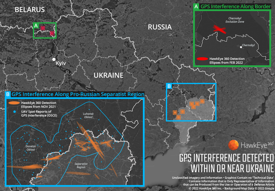
HawkEye 360 proved that point in a March 4 news release on GPS interference in and around Ukraine over the last four months. Prior to the Russia’s Feb. 24 invasion of Ukraine, the Herndon, Virginia-based geospatial analytics company noted continual and increasing GPS interference near Ukraine.
“GPS is a fundamental ‘global commons’ service that all modern economies depend upon,” HawkEye 360 CEO John Serafini said in a statement. “GPS signal interference has the potential to significantly disrupt air travel, logistics, finance, transportation, communication and many other basic services.”
HawkEye 360’s satellite constellation monitors radio frequency signals for interference that might threaten military and civil navigation applications. The capability, which the company demonstrated last year, is now part of its product catalogue.
HawkEye 360 analysts increasing GPS interference north of Chernobyl near the border Ukraine-Belarus border.
Shortly before the Russian invasion began, HawkEye 360 analysts detected GPS interference north of Chernobyl, “demonstrating the integration of electronic warfare tactics into Russian military operation to further degrade Ukraine’s ability for self-defense,” according to the HawkEye 360 news release.
In November, HawkEye 360 also noted GPS interference near the border between pro-Ukrainian forces and Russian-backed forces in the Luhansk and Donetsk region. With publicly available information, the company confirmed that the operation of unpiloted aircraft in the region were disrupted by the interference.
GPS interference is not always deliberate. It can be caused accidentally by communications signals operating close to GPS frequency bands. Nevertheless, the world’s growing reliance on GPS has prompted military forces and drug cartels to invest in equipment to jam or spoof GPS signals, and for the U.S. government to look for backup sources of reliable position, navigation and timing data.
“Whether unintentional or deliberate, interference that prevents people, vehicles, ships and planes from determining accurate locations can be devastating to government and commercial activities alike,” Serafini said. “Since HawkEye 360 can monitor hundreds of millions of square kilometers daily, we are able to notify clients when and where GPS interference occurs, so they can respond quickly to mitigate the impacts.”
